Kilburn
Kilburn History
Kilburn is an area in Brent, which grew around the intersection of the Roman Watling Street (Edgware Road) and a local river of the same name. Kilburn lies south west of this stretch of the ancient thoroughfare, here called Kilburn High Road, between West End Lane and Queen’s Park.
The name ‘Kilburn’ could have several origins. Some say it comes from a stream (Anglo-Saxon Kelebourne, which could have been ‘cold bourne’ (river), ‘cow’s bourne’ or ‘King’s bourne’), which used to flow into the River Westbourne, which flows from Hampstead to the Serpentine in Hyde Park. Or it could be named after a Saxon called Cylla, used c. 1134 as Cuneburna). A variation of Kilnbourn could come from tile making industry in the area.
As well as enabling quick movement of Roman troops and resources to provinces, Watling Street served as a boundary: in 878 King Alfred and the Danes signed a treaty, according to which King Alfred kept the southern side – Wessex, and the Danes established Danelaw to the north. In 1599 Watling Street is mentioned as London Way, and later the Edgware Road. Our stretch of it has become the traditional boundary between Willesden, now in Brent, and Hampstead, now in Camden.
A community of Augustinian canonesses, Kilburn Priory was set up where the Watling Road crossed the Kilburn brook in the 12th century. Now Belsize Road meets Kilburn High Road here. The Priory was a stopping place for pilgrims on their way to the shrines at St.Albans or Willesden, and, according to the customs of the time, provided food and shelter to travellers, both rich and poor. Pilgrims had to travel through woods, which afforded hiding places for robbers, particularly at the foot of the nearby Shoot up Hill, and a safe resting place was very helpful for pilgrims to form groups to travel together for protection. This hospitality proved a burden on the Priory, and by the middle of 14th century it was found in financial trouble by the Bishop of London and in 1352 was exempt from taxes. By the end of the century its buildings were in decay. The Priory continued to support travellers for 400 years, so it never became wealthy. It was dissolved by Henry VIII in 1536 Henry VIII. Later landowners, the Uptons built the Church of St. Mary on a site adjoining the ancient chapel of the priory. The echoes of the Priory are found in many local street names, such as Abbey Road and Priory Road. (More on this in WLH Journal 49).
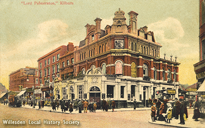
A spring of water with medicinal properties (it was impregnated with iron) in Abbey Fields gave rise to Kilburn’s reputation as an 18th century pleasure resort. It was in the grounds of The Bell pub. Soon it acquired a notorious reputation, as it attracted visitors from the nearby Belsize House, an immoral place of entertainment. Despite the fact that at the height of its popularity Kilburn Wells could rival the nearby Hampstead Wells, some of its owners went bankrupt. In 1837 the line of the London & Birmingham Railway (later the London & North Western) went through Abbey Farm fields, cutting the Kilburn Wells gardens in two. The part next to the pub because a tea garden, and the part on the other side of the railway, which contained the well, became a kitchen garden.The Old Bell pub was demolished and rebuilt in 1863. The well disappeared in the Victorian building boom. The memory of Kilburn Wells lives in the name of the Wells Spa House (1a West End Lane), and a stone plaque on No.42 Kilburn High Road at the junction with Belsize Road, which says that this was the site of Kilburn Wells, as well as a black stone square on the ground in front of the building.
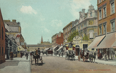
17th and 18th century Kilburn was mostly rural, with some houses and cottages long the Edgware Road, as well as a number of inns catering for coach services along the main road. The part of Kilburn on the Willesden side belonged to the manors of Bounds, Brondesbury and Mapesbury.
Several large houses were of note in the area. One of those was the Manor House, on a site between today’s Oxford and Cambridge Roads. In the 18th century it was owned by Dame Sarah Salusbury, the widow of Sir Thomas Salusbury, Judge of the High Court of the Admiralty. It later passed to other family members, until a later Lady Salusbury sold her properties to the Church Commissioners in 1856, and the land was built up with housing. The name of Salusbury lives on today, in the name of road, the school situated on it, as well as a pub, wine store and other local amenities.
Kilburn House, a pleasant suburban villa with extensive grounds, was situated north of today’s Kilburn Square near Priory Park Road. Between 1839 and 1856 the newsagent and future First Lord of the Admiralty W.H.Smith lived here with his father, when they moved the family home from their offices in Strand.
The railway lines began crossing Kilburn’s land in 1837, with the coming of The London and Birmingham Railway. Kilburn High Road station opened in 1851. In 1860s Edgware Road (later Brondesbury) station came on the Hampstead Junction Railway, and Kilburn and Brondesbury (Kilburn today) station was opened on the Metropolitan Railway in 1879.
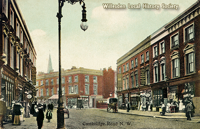
In the second half of the 19th century house building expanded, from South Kilburn moving northwards. Businesses like United Land Company would purchase plots of land, subdivide them into smaller plots and sell those at auctions, resulting in smaller developers doing the actual building. Land owners or builders were also responsible for the infrastructure of their own developments, including roads and sewers. Retail centres, businesses, local amenities, churches and schools sprang up to cater for the needs of the residents. Willesden Town Hall opened in Dyne Road in 1891. The building demolished in 1970.
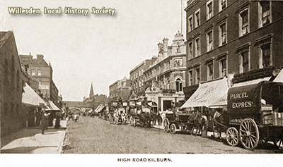
By the end of the 19th century Salusbury Road featured a fire service station, a library and a police station. Kilburn became a thriving commercial centre, with Kilburn High Road featuring a continuous line of shops by 1860s. Foyle’s bookshop started in Kilburn, moving to Charing Cross Road in 1926. By 1909 there were 300 shops here, many owned by foreigners, some of them Jewish immigrants. In terms of industry, in addition to traditional tile making in the area, by 1890 there were coachbuilders, bicycle manufacturers, monumental masons (for Paddington Cemetery) and a railway signal factory based in Kilburn Lane (later called Canterbury Road) – Saxby & Farmer’s, which was the largest employer in Kilburn. Light engineering and printing were also established by 1914.
The beautiful church of is St. Augustine’s Church in Kilburn Park Road, known as “the Cathedral of North London”, was consecrated in 1880 as Anglo-Catholic Church of England and is now Grade II listed.
Kilburn Grammar School was founded in 1897 as a private boys’ school and moved to its permanent purpose-built home at Salusbury Road in 1900. In 1907 the school was purchased by the local authorities and became the first state secondary school in Willesden. With the formation of Brent in 1964, the borough policy of closing grammar schools lead to the school becoming a comprehensive in 1967, renamed. Kilburn Senior High School. In 1973 it merged with the girl’s school on the opposite side of the road to form Brondesbury and Kilburn High School, and in 1989 it moved to a different place and became part of Queen’s Park Community School. The Edwardian buildings in Salusbury Road are now Islamia Schools.
Kilburn had a large number of private schools. Of note are Henley House School at the corner of Kilburn Priory, which was headed by John Vine Milne, whose son Alan Alexander, author of Winnie the Pooh stories, was born there in 1882. The first science teacher at Henley House, appointed in 1888 was H.G.Wells, the pioneer of science fiction.
Kilburn’s position on the Edgware Road ensured a good number of drinking establishments from early times. The public houses were much more than a place for a pint – they were hotels, functions rooms, auction sites, coroners’ inquests premises, even makeshift mortuaries. By 1872 there were 8 pubs in Kilburn High Road, and 13 more in the neighbourhood. There was a brewery and several beer retailers.
There were several theatres and cinemas, the grandest of which was the Gaumont State Cinema, opened in 1937. It seated 4,000 people, had a Wurlitzer organ, a separate dance hall and a restaurant. It was the largest cinema in Europe at the time, and remains the third largest ever built in the UK. Over the years it featured such acts as Gracie Fields, George Formby, Buddy Holly, Jerry Lee Lewis, Ella Fitzgerald, the Beatles, the Rolling Stones, David Bowie, the Who and many others. It is now a church.
You can find more information on music venue in Willesden on Music Maps here – https://www.notjustcamden.uk/maps/
The turn of the new century witnessed the growing divide in Kilburn between the more prosperous north and poor south, where overcrowded houses offered dire conditions and were full of diseases. In the 1930s some new developments, in particular on Shoot Up Hill, took the form of blocks of flats. Large scale municipal housing emerged between the first and second World Wars.
After the war the Greater London Plan was brought about the redevelopment of Kilburn. Obsolete industry, overcrowded and dilapidated slums were to be replaced with housing. Unfortunately, many Victorian buildings also had to go. In the early 1960s Kilburn Square saw the replacement of its 3/4 storey Victorian terrace houses with a shopping centre, along with a 17 storey block of flats labelled ‘pocket skyscraper’.
Many of the building labourers engaged on these schemes were Irish. Despite earlier Irish immigration it was now, partly because of the large number of furnished rooms available for rent, that the suburb truly became ‘County Kilburn’.
Redevelopment started in 1951 in Kilburn Vale and 1954 in south Kilburn, where the average population density was 10 people to a house and where some houses were actually falling down. Redevelopment scheme extended in 1963, with final developments in 1970s.
The resulting estate of typical 1960s brutalist style high density housing in low rise flats and 11 concrete tower blocks was plagued by crime, shootings, gun and drug trade.
In 2004 Brent Council started working on a 15 year plan of drastic demolition of much of the estate and creating a new living environment, at a cost of £660 million. The demolition of the old estate started in 2014 with two of the 18 storey housing blocks, to be replaced with 4 ‘smart’ blocks and amenities for the local community. Despite the council’s efforts to improve the quality of the area, it continues to be plagued by problems connected to its history of gang violence and drug dealing, as well as issues with maintenance of the newly built homes and cladding for fire safety regulations.
From 1970s onwards the Irish population started to move out of the area, and immigrants from the Caribbean, Middle East and Asia started to come in. Today it is a thriving multi-cultural area, full of vigour and variety, and we hope that its historic heritage will be preserved in years to come.
Irina Porter, 2021