Church End and Chapel End
The History of Church End and Chapel End
Church End lies between Harlesden and Willesden Green. The medieval hamlet of Church End grew up around the Parish Church of St. Mary, Willesden, at the junction of Church Road, Willesden Lane, (later renamed Willesden High Road,) and Neasden Lane. Other villages in Willesden parish, such as Harlesden, Neasden and Oxgate, date from the Anglo-Saxon period, and were already established by the time of the Norman Conquest, 1066. St. Paul’s Cathedral owned much of the land in Willesden, including the area between Harlesden and Willesden Green. There is no mention of a church in the Domesday Survey of 20 years later; there might have been an earlier, Saxon church on the site of St. Mary’s. However, no evidence has ever been found.
By the 12th Century, a small stone Church had been built on the site. An “inquisition” or visitation from St. Paul’s Cathedral, in 1181 AD, records the church and its contents. Soon after, by 1200 AD, the little Church was increased in size, and a tower and side aisles were added. The 800 year history of the St. Mary’ has been well-documented by our best local historians. It has weathered storms, wars, plagues, famines, times of social turmoil, neglect, restorations, calls for its demolition, yet survives to this day, surrounded by the quiet Churchyard, the resting place of generations of Willesden people, at the centre of Church End.
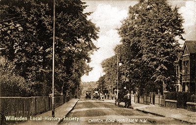
CHURCH END VILLAGE. It was described as “A very retired little village, with its Church, Rectory and Vicarage, and about 20 cottages, housing among others a butcher, a bricklayer and a general dealer. There was a group of wooden poorhouse dwellings in the churchyard.” This was written by Harrison Ainsworth, who lived at Kensal Manor on the Harrow Road, in 1830.The little village was to go through great changes in the 19th Century. The first railway to be built across Church End was the Acton Branch of the Midland and South West Junction Railway, crossing the area to Cricklewood. This cut Church End off from the fields to the north and west, and foretold the demise of the farming way of life which had survived for so long.
People were attracted to Church End to find work in the 19th Century, and landowners began to sell off farm land for house building, after the Acts of Enclosure were passed by Parliament. The land at Church End was part of the Rectory Estate of the old Manor of Willesden. John Nicoll of Neasden had purchased the Rectory Estate, back in 1738, and after passing through several hands in the early 19th Century, it was sold to the United Land Company in 1869. Developers and builders were able to buy plots of land at auction. Nine acres at Church End Paddocks were sold off in 1873. The Church Farm Estate went up for sale in 1875, (this was a 4-acre plot next to the White Horse pub, which became the Cobbold Road estate.) Building on the United Land Company’s Estates was finished by the mid-1890s. Southward expansion was prevented by the opening of the Jewish Cemetery in 1873, and Willesden New Cemetery, in 1893.
The plots of land sold to builders were quite small, small houses were built, and the area became working class. Amenities such as schools, shops, pubs and meeting rooms were built alongside the new houses.
CHAPEL END. A brick Chapel was built by non-conformist villagers to the east of the Church End settlement, in 1820. The name Chapel End soon came into use. The residents felt themselves to be different from the people of Church End. Within a few years, Chapel End was sometimes called “Queenstown,” supposedly to commemorate a visit by Queen Victoria. There does not seem to be any record of such a visit, and the name might simply be a remembrance of Queen Victoria’s accession in 1837. The small original Chapel at the corner of Dudden Hill Lane was replaced by a much larger Chapel, on the corner of Willesden High Road opposite Pound Lane. The small Chapel was used as a Sunday school, then demolished for road widening in 1908. The large Chapel is still in use today.
LANDMARKS OF CHURCH END. The population of the village increased during the 19th Century, needing amenities, in addition to housing. ST MARY’S SCHOOL was one of the earliest schools to be built in Willesden. The local Vestry decided, in 1809, to establish a Sunday School for 80 children of the poor, giving them the chance to learn to read and write. Local farmers relied on child labour at certain times of the year, and were less than impressed by the plan, thinking that the youngsters would get ideas “above their station.” The original Sunday School became a day school in 1818, then moved into a new building beside Willesden High Road, in 1853. The school remained in use until 1972, when it was replaced by a new Primary School at Garnet Road, on the Church End Estate. Willesden Magistrates Court replaced the old St. Mary’s School.
THE INFANTS SCHOOL, POUND LANE. This small school, for Infants only, was opened in 1858, on land donated by All Souls’ College, Oxford. The building still survives, now used by an Evangelical Church.
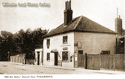
PUBLIC HOUSES. Some of these were among the earliest amenities to appear in the village, after the Church. The Five Bells was built before 1724, its name changed to The Six Bells when the ring at St Mary’s Church nearby was augmented to six. The White Hart, built 1749, and White Horse, 1888, were built beside Church Road, both popular centres for social activities. The White Hart provided grounds for the Neasden Cycling Club and Finchley Harriers Running club. Both these pubs have been demolished.
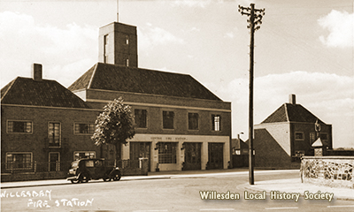
VESTRY HALL. Built as a meeting room for the Willesden Vestry (forerunner of the local Council), in 1857, this survivor was a fire station, and more recently a children’s nursery, and Food bank. It can still be seen beside St. Mary’s Church Cottages, opposite the Church.
THE GRANADA CINEMA, Church Road, opened in 1921, closed in 1962, and has survived as flats with a Church on the ground floor.
LANDMARKS OF CHAPEL END. As well as the Chapels, this end of the Church End area had a POUND for stray animals until 1886, at the corner of Pound Lane. Two PUBS, The Crown, and The Case is Altered were built on the High Road. The Crown has been empty for several years, but the Case is still trading.
THE WILLESDEN GREEN ELECTRIC PALACE was Chapel End’s small Cinema at the corner of Dudden Hill Lane, now demolished .The mission Church of ST. JOHN THE BAPTIST is still on Dudden Hill Lane, now used as a Community Centre.
POUND LANE DRILL HALL, used for military training in the early 20th Century, has been replaced by St Mungo’s Hostel.
WILLESDEN BUS GARAGE has been an important local employer for more than 100 years, beginning with horse drawn buses in 1900.
DEVELOPMENT OF INDUSTRY. Church End after the First World War still had large areas of land which had not been used for house-building, unlike Willesden Green, which was covered in new terraces of houses. The remaining fields in Church End and Chapel End were opened up by companies like British Thomson Houston, the electrical engineering firm, which built its workshops on the cricket field north of St. Mary’s vicarage, in 1919. J.H. Dallmeyer, optical instrument makers, opened on Willesden High Road in 1920. The coach builders, Park Ward, opened at Church End in 1919, later trading as Rolls Royce Motors, Mulliner Park Ward division.
Other engineering companies produced bus and heavy goods vehicle bodies. The nearby railway sheds of the Metropolitan Line, and Great Central Railway, were also important employers.
By 1936, Church End was almost wholly industrial. 14 percent of the population of the Borough of Willesden were employed at Church End and Chapel End by 1939. After the Second World War, the area was recognised to be over-industrialised, and the GLC began to encourage firms to move out to New Towns, like Stevenage, Hemel Hempstead and Welwyn Garden City. The vacated factory sites and workshops were given over to warehouses, retail outlets, trading areas and other non-manufacturing concerns. The latest trend is the development of high-density housing on every available site, to accommodate the ever-growing population.